The Everest Base Camp trek on the south side is one of the most popular trekking routes in the Himalayas and is visited by thousands of trekkers each year.
In 2015, it was noted that about 40,000 people per year take the trek from the Lukla airport to the Nepal Everest Base Camp.
From Lukla, climbers trek upward to the Sherpa capital of Namche Bazaar, 3,440 metres (11,290 ft), following the valley of the Dudh Kosi river. It takes about two days to reach the village, which is a central hub of the area. Typically at this point, climbers allow a day of rest for acclimatization. They then trek another two days to Dingboche, 4,260 metres (13,980 ft) before resting for another day for further acclimatization. Another two days takes them to Everest Base Camp via Gorakshep, the flat field below Kala Patthar, 5,545 metres (18,192 ft) and Mt. Pumori
On 25 April 2015 an earthquake measuring 7.8 Mw struck Nepal and triggered an avalanche on Pumori that swept through the South Base Camp. At least 19 people were said to have been killed as a result.
Just over two weeks later, on May 12, a second quake struck measuring 7.3 on themoment magnitude scale. Some of the trails leading to Everest Base Camp were damaged by these earthquakes and needed repairs.
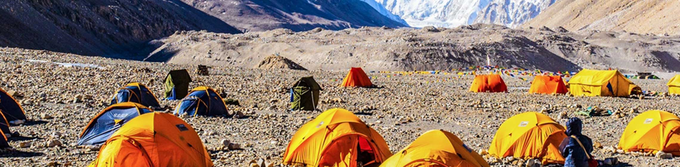
Everest Base Camp trek is intended as a starting point for any climber to get used to high altitude conditions and reduce chances of altitude sickness. The camp presents a primitive row of tent and toilet facilities with minimal amenities. Everest Base Camp trek is situated around 17,500 feet high and is certainly not an easy challenge to overcome.
Location. Everest Base Camp is located in the Khumbu Valley in Nepal surrounded by the Sagarmatha National Park.
Duration of your Everest Base Camp Trek is usually 10 days for experienced climbers allowing you to take your time and progress gradually to get acclimatized to high altitude changes along the way. The duration of the Everest Base Camp Trek is usually extended to 17 days for amateur or inexperienced climbers.
Climate is extreme in the Everest Base Camp area and weather can change in mere minutes.
altitude sickness is a very dangerous medical condition caused by low oxygen levels in blood and should not be taken lightly.
The best ways to cope with high altitude conditions are drinking purified water and taking your time climbing to allow for proper acclimatization.
On the last earthquake, one avalanche, originating on the nearby peak of Pumori, swept into South Base Camp and then through part of the Khumbu Icefall. An Indian Army mountaineering team recovered the bodies of 19 mountaineers from the South Base Camp and rescued at least 61 stranded climbers from the mountain
Shaking from the quake triggered an avalanche fromPumori into the basecamp on Mount Everest. At least twenty-two people were killed, surpassing an avalanche that occurred the previous year as the deadliest disaster on the mountain.
Mount Everest was approximately 220 kilometres (140 mi) east of the epicentre, and between 700 and 1,000 people were on or near the mountain when the earthquake struck, including 359 climbers at Base Camp, many of whom had returned after the aborted 2014 season. The earthquake triggered several large avalanches on and around the mountain.
Most people experience an altitude headache, loss of appetite and poor-quality sleep at some point. This is mild altitude sickness and is quite normal (and quite bearable). Also, it shouldn’t last for long. There is a chance you’ll experience worse symptoms, but they are easily treated by descending – often they will disappear with just a couple of hundred metres of descent
The Khumbu Glacier is located in the Khumbu region of northeastern Nepal between Mount Everest and the Lhotse-Nuptse ridge. With elevations of 4,900 m (16,100 ft) at its terminus to 7,600 m (24,900 ft) at its source, it is the world's highest glacier.
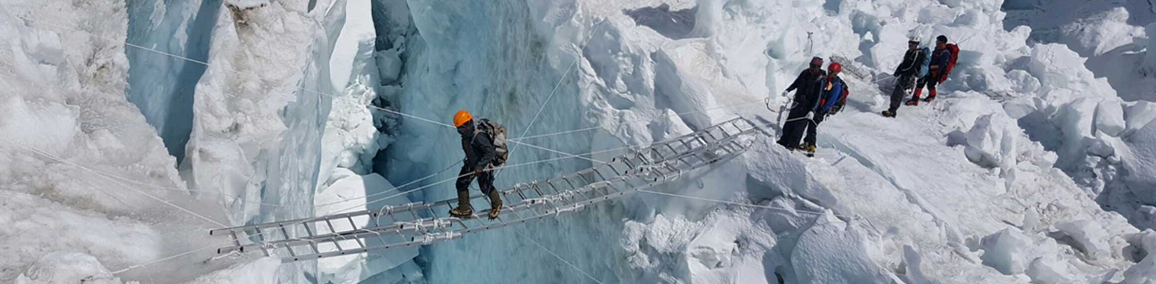
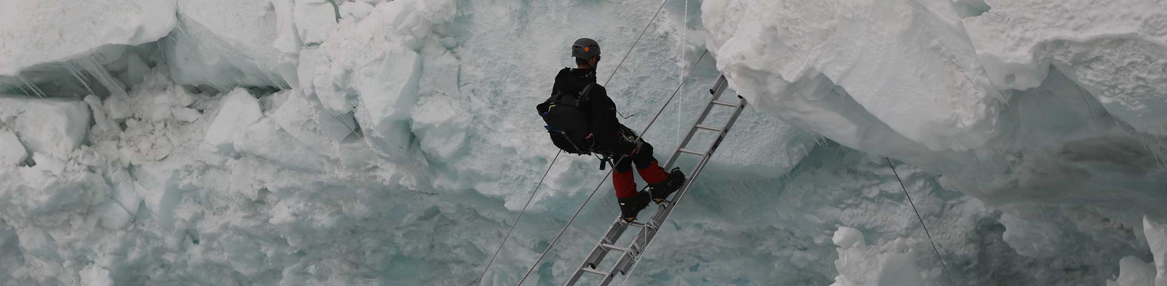
The Khumbu Glacier is followed for the final part of the trail to one of the Everest Base Camps. The start of the glacier is in the Western Cwm near Everest. The glacier has a large icefall, the Khumbu Icefall, at the west end of the lower Western Cwm.
This icefall is the first major obstacle—and among the more dangerous—on the standard south col route to the Everest summit.
The end of Khumbu Glacier is located at 27.932N and 86.805E.
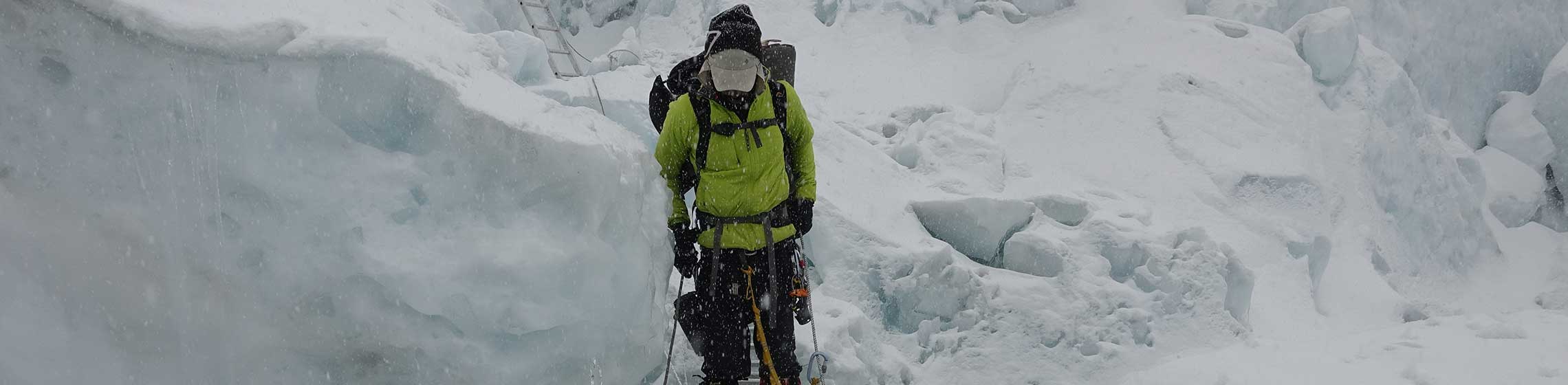
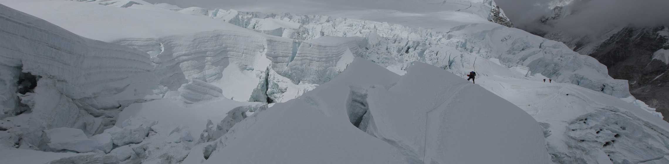
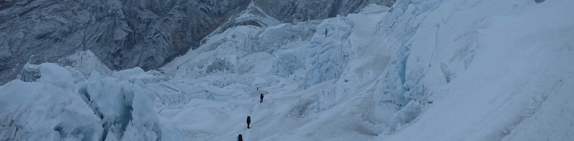
The Khumbu Icefall is an icefall located at the head of the Khumbu Glacier and the foot of the Western Cwm, which lies at an altitude of 5,486 metres (17,999 ft) on the Nepali slopes of Mount Everest, not far above Base Camp and southwest of the summit.
The icefall is considered one of the most dangerous stages of the South Col route to Everest's summit
The Khumbu glacier that forms the icefall moves at such speed that large crevasses open with little warning, and the large towers of ice (called seracs) found at the icefall have been known to collapse suddenly. Huge blocks of ice tumble down the glacier from time to time, their size ranging from that of cars to large houses. It is estimated that the glacier advances 0.9 to 1.2 m (3 to 4 ft) down the mountain every day.
Most climbers try to cross the icefall during the very early morning, before sunrise, when it has partially frozen during the night and is less susceptible to movement. As the intense sunlight warms the area, the friction between the ice structure lessens and increases the chances of crevasses opening or blocks falling. The most dangerous time to cross the Khumbu Icefall is generally mid- to late-afternoon
Strong, acclimatized climbers can ascend the icefall in a few hours, while climbers going through it for the first time, or lacking acclimatization or experience, tend to make the journey in 10–12 hours. "Camp I" on Everest's South Col route is typically slightly beyond the top of the Khumbu Icefall.
If a climber is caught in an avalanche or other "movement" event in the icefall, there is very little they can do except prepare for potential entrapment by heavy blocks of ice or immediate movement afterwards, to try to rescue others. It is virtually impossible to run away or even to know which way to run.
Some people who have died in the icefall and whose bodies have not been recovered have reportedly shown up at the base of the icefall many years later, as the ice continually migrates downward toward Everest Base Camp.
Since the structures are continually changing, crossing the Khumbu Icefall is extremely dangerous. Even extensive rope and ladder crossings cannot prevent loss of life. Many people have died in this area, such as a climber who was crushed by a 12-story block of solid ice. Exposed crevasses may be easy to avoid, but some may be hidden under dangerous snow bridges, through which unwary climbers can fall.
Around 6:30 am local time, on the morning of 18 April 2014, 16 Nepalese climbers were killed by an avalanche in the Khumbu Icefall. As of 22 April, 13 bodies had been recovered, and three remained missing, presumed dead. The climbers were preparing the route through the dangerous icefall for the spring climbing season when the avalanche engulfed them. Nine others sustained blunt trauma injuries.
Camp 1 is a vast, flat area of endless snow, deep crevasses and mountain walls frequently washed by avalanches.
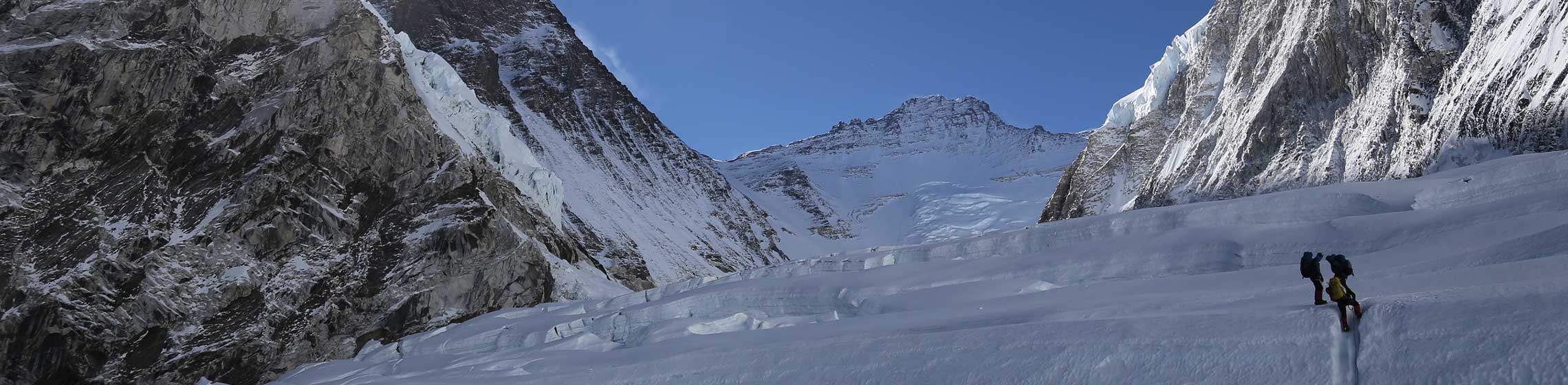
The area between Camp I and Camp II is known as the Western Cwm.
From Camp I, climbers make their way up the Western Cwm to the base of the Lhotse face, where Camp II or Advanced Base Camp (ABC) is established at 6,500 m (21,300 ft). The Western Cwm is a flat, gently rising glacial valley, marked by huge lateral crevasses in the centre, which prevent direct access to the upper reaches of the Cwm. Climbers are forced to cross on the far right near the base of Nuptse to a small passageway known as the "Nuptse corner". The Western Cwm is also called the "Valley of Silence" as the topography of the area generally cuts off wind from the climbing route. The high altitude and a clear, windless day can make the Western Cwm unbearably hot for climbers
A rocky patch, at the foot of the icy Lhotse wall. This marks camp 2. This place is absolutely stunning. Clouds roll in from the lower ranges of the Himalayas, up the valley and into the camp.
From Advanced Base Camp (ABC), climbers ascend the Lhotse face on fixed ropes up to Camp III, located on a small ledge at 7,470 m (24,500 ft).
The camp here is a true eagle's nest, placed right out of the wall. Going to the toilet at night is a tedious task to dress and secure oneself. In addition, just to find a spot for it on this narrow platform is tricky enough. But the view is grand and by now you are well on your way to the summit.
To reach Camp III, climbers must negotiate the Lhotse Face. Climbing a sheer wall of ice demands skill, strength and stamina. It is so steep and treacherous that many Sherpas move directly from Camp II to Camp IV on the South Col, refusing to stay on the Lhotse Face.
From there, it is another 500 meters to Camp IV on the South Col at 7,920 m (26,000 ft). From Camp III to Camp IV, climbers are faced with two additional challenges: the Geneva Spurand the Yellow Band. The Geneva Spur is an anvil shaped rib of black rock named by the 1952 Swiss expedition. Fixed ropes assist climbers in scramblingover this snow-covered rock band. The Yellow Band is a section of interlayered marble, phyllite, and semischist, which also requires about 100 meters of rope for traversing it.
Camp IV, which is at 26,300 on the Lhotse face, is typically the climbers' first overnight stay in the Death Zone. The Death Zone is above 26,000 feet. Though there is nothing magical about that altitude, it is at this altitude that most human bodies lose all ability to acclimate. Accordingly, the body slowly begins to deteriorate and die - thus, the name "Death Zone." The longer a climber stays at this altitude, the more likely illness (HACE - high altitude cerebral edema - or HAPE - high altitude pulmonary edema) or death will occur.
Camp IV is located at 26,300 feet. This is the final major camp for the summit push. It is at this point that the climbers make their final preparations. It is also a haven for worn-out climbers on their exhausting descent from summit attempts (both successful and not). Sherpas or other climbers will often wait here with supplies and hot tea for returning climbers.
From Camp IV, climbers will push through the Balcony, at 27,500 feet, to the Hillary Step at 28,800 feet. The Hillary Step, an over 70 foot rock step, is named after Sir. Edmond Hillary, who in 1953, along with Tenzing Norgay, became the first people to summit Everest. The Hillary Step, which is climbed with fixed ropes, often becomes a bottleneck as only one climber can climb at a time. Though the Hillary Step would not be difficult at sea level for experienced climbers, at Everest's altitude, it is considered the most technically challenging aspect of the climb.
Coldest Temperature on Summit: -41ºC (-42F)
Warmest Temperature on Summit: -16ºC (3F)
Highest Windspeed Everest: 175mph+ (Category 5 Hurricane Equivalent)
Everest Summit is the Windiest Location on Earth
Unique Clouds: Banner Clouds form only on Everest and the Matterhorn
Sir Edmund Hillary and Sherpa Tenzing Norgay became the first people to stand on the elusive summit on May 29, 1953
These courageous climbers ascended through to the South Col from the Khumbu Glacier, and continued their ascent to the summit via the Southeast Ridge. Their route is now referred to as the Normal Route.
The summit of Everest has been described as "the size of a dining room table"
The summit is capped with snow over ice over rock, and the layer of snow varies year to year
Below the summit there is an area known as "rainbow valley", filled with dead bodies still wearing brightly coloured winter gear.
Below the summit the mountain slopes downward to the three main sides, or faces, of Mount Everest: the North Face, the South-West Face, and the East/Kangshung Face.